South Jordan Transportation Guide — TRAX, Bangerter, I-15, Trails & Commute Fit
Transportation in South Jordan is not just about map distance. It is about your real Tuesday: commute timing, school drop-off, Bangerter access, I-15 backup routes, TRAX usefulness, trail connections, errands, and whether the first ten minutes from your driveway feel calm or frustrating.
My quick answer: South Jordan can be a very practical home base if your pocket lines up with your commute, school routine, errands loop, and comfort with driving or transit. But transportation here should be evaluated from the exact address, not from the city name. A home near Daybreak, a home near Bangerter, a home closer to I-15, and a home near a TRAX station can all create very different weekday patterns.
When I help you compare South Jordan homes, I do not ask only, “How far is it from work?” I ask: What time do you leave? Do you have school drop-off first? Are you using Bangerter, Mountain View Corridor, I-15, or TRAX? Is there a realistic backup route? Do you need quick access to Draper, Lehi, downtown Salt Lake City, the airport, or local schools and activities?
This page uses UTA Red Line schedule resources and the March 2025 South Jordan Downtown Station announcement, Census commute data, South Jordan City transportation and trail updates, UDOT/Bangerter corridor updates, and Daybreak/Downtown Daybreak context. Commute times, transit schedules, station access, school routes, road conditions, event traffic, and construction impacts can change. Always verify for the exact address and your real travel window.
Sources checked: UTA Red Line schedule and station announcement, South Jordan City transportation/trail updates, South Jordan City Bangerter interchange completion notice, UDOT project/current-condition resources, and U.S. Census QuickFacts commute data.
What changed in this update: Added station-by-station guidance, a commute-by-pocket matrix, a current-projects table, stronger Downtown Daybreak/event-traffic cautions, and more address-level verification steps.
South Jordan transportation snapshot: the practical facts to know first
South Jordan sits in a useful but nuanced part of the Salt Lake Valley. It connects west-side master-planned neighborhoods, central commercial corridors, east-side I-15 access, TRAX service into the Daybreak side of the city, and active-transportation investments that support walking and biking in specific corridors.
The broad picture is positive: South Jordan gives many households several ways to move. The practical question is whether the specific home puts you near the mode or route you will actually use.
- UTA Route 703 — TRAX Red Line Schedule
- UTA — South Jordan Downtown Station opening
- U.S. Census Bureau QuickFacts for South Jordan
- South Jordan City — Bangerter interchange completion
- South Jordan City — transit and trail connectivity update
- South Jordan City — 2026 infrastructure update
- UDOT Current Conditions
The key is not whether South Jordan has access. It does. The key is whether your chosen pocket gives you access in the direction and time window you need.
The Tuesday test: the simplest way to avoid commute regret
Transportation decisions go wrong when buyers use best-case timing. A Sunday afternoon drive does not tell you what your life will feel like when school is in session, weather is messy, and everyone else is trying to get to work too.
I like to use what I call the Tuesday test. It is simple: test the exact route on a normal weekday, at the time you will actually leave, with the real stops you will actually make.
- Start from the exact listing address.
Do not use the neighborhood name or a nearby intersection. Use the driveway location if possible. - Choose your real departure time.
Test 7:15 a.m., 7:45 a.m., 8:30 a.m., or whatever your actual schedule requires. - Add school drop-off if it applies.
A commute and school route can both look fine separately but feel hard together. - Test the evening return.
Your morning may be manageable, but the 5–6 p.m. return can reveal the real stress point. - Identify one backup route.
If your route has only one realistic option, you need to be comfortable with that vulnerability. - Track variability, not just average time.
A predictable 28 minutes may feel better than a route that is sometimes 18 minutes and sometimes 48.
Road corridors: Bangerter, I-15, Mountain View Corridor, and local east-west movement
South Jordan transportation is shaped by a few major corridors. Each one serves a different lifestyle. East-side commuters may care more about I-15 access. West-side and Daybreak-area buyers may care more about Mountain View Corridor, Bangerter, and TRAX station access. Families may care most about the first ten minutes around schools, errands, and activities.
| Corridor | Best for | What to verify |
|---|---|---|
| I-15 | Regional access toward downtown Salt Lake City, Sandy, Draper, Lehi, Silicon Slopes, and longer north-south trips. | Actual time from the home to the on-ramp, weekday congestion, incident vulnerability, and backup routes. |
| Bangerter Highway | Central and west-side valley movement, airport-side access, commercial corridors, and cross-valley trips. | Current interchange construction, lane shifts, access points, and whether recent or planned upgrades affect your route. |
| Mountain View Corridor | West South Jordan, Daybreak, Herriman/Riverton connections, and western Salt Lake County movement. | Distance from the home, access points, growth-related traffic, and whether your destination aligns with the corridor. |
| 11400 S / 10400 S / 10600 S routes | East-west connections between neighborhoods, schools, shopping, TRAX, and major roads. | School timing, turn movements, traffic signals, pedestrian crossings, and how the route feels after work. |
| Neighborhood collectors | The first and last few minutes of your commute, school run, and errands loop. | Parking, school congestion, stop signs, neighborhood cut-through traffic, and winter conditions. |
UDOT’s Bangerter project resources describe freeway-style interchange work along the corridor, including major completed or active interchange work in the region. UDOT and local project pages should be checked before relying on route timing because construction schedules, lane shifts, and project impacts can change.
Commute-by-pocket matrix: South Jordan does not commute the same from every area
A South Jordan address can be very practical, but the right pocket depends on where your week points you. Daybreak, Downtown Daybreak, central South Jordan, and east-side South Jordan can each feel different because the first ten minutes from the driveway change everything.
| South Jordan pocket | Usually strongest for | Main access pattern | What to test before buying |
|---|---|---|---|
| Downtown Daybreak / Ballpark District | TRAX users, event/dining access, walkable-node buyers, and people who like activity nearby. | South Jordan Downtown Station, local Daybreak streets, Mountain View/Bangerter connections depending on destination. | Event-night traffic, parking, station walking route, sound/activity tolerance, and whether Red Line timing fits your real destination. |
| West Daybreak / Daybreak Parkway side | Buyers who value west-side access, newer planned-community pockets, trails, and Red Line end-of-line access. | Daybreak Parkway Station, Mountain View Corridor, local collectors, and Bangerter depending on route. | Drive-to-station timing, park-and-ride practicality, distance to I-15, and future growth/construction around the route. |
| Central South Jordan | Households that want a flexible middle position for schools, errands, Bangerter, and local commercial areas. | Bangerter, 10400 S/10600 S/11400 S east-west routes, local school and errands loops. | Peak-hour intersections, school timing, left turns, backup route options, and whether errands are genuinely low-friction. |
| East South Jordan / I-15 side | Commuters heading toward Sandy, Murray, Draper, Lehi, downtown SLC, or I-15-heavy work patterns. | I-15, South Jordan Gateway/FrontRunner influence area, east-west local routes to reach the freeway. | First-mile time to the freeway, I-15 variability, FrontRunner/park-and-ride usefulness, and evening return congestion. |
| Redwood / Jordan River influence areas | Buyers who need north-south valley movement, Redwood Road access, trails, or bus/transit options in specific corridors. | Redwood Road, Route 219 corridor, Jordan River Parkway connections, and east-west routes toward TRAX or I-15. | Bus schedule fit, pedestrian crossings, trail access points, and whether your daily destinations sit east, west, north, or south. |
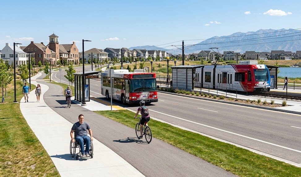
TRAX and transit: where rail access can actually matter
South Jordan’s strongest public-transit story is the UTA TRAX Red Line connection on the west side of the city and Daybreak area. For the right household, Red Line access can make downtown Salt Lake City, the University of Utah corridor, events, and car-light routines more realistic.
But I would not assume “near TRAX” automatically means the home is transit-friendly. You need to verify station distance, parking, walking route, schedule, transfer needs, safety comfort, winter practicality, and whether your actual destination works by rail.
Question: Is TRAX useful for daily commuting?
It can be, especially if your destination aligns with the Red Line or a clean transfer. It is less useful if the station access is awkward, your final destination requires too many extra steps, or your work schedule does not match service timing.
Question: Should I pay more to be near a station?
Only if you will actually use it or if the location also improves your broader routine. Station proximity can be valuable, but not if you still drive everywhere and the home creates other daily friction.
| Transit factor | Why it matters | How to verify |
|---|---|---|
| Station distance | A station can be close on a map but inconvenient in practice. | Walk or drive from the home to the station during your real departure time. |
| Parking | If you drive to the station, parking availability becomes part of the commute. | Check station parking during your actual travel window, not midday. |
| Schedule and frequency | Your schedule needs to match service reality. | Review UTA’s current Red Line schedule and service alerts before relying on transit. |
| Transfers | Transfers can make a commute less predictable or less comfortable. | Plan the full door-to-door route, including walking, waiting, and final-mile travel. |
| Weather and winter | Cold, snow, and darkness change station access and walking comfort. | Evaluate the route in winter conditions if you plan to use transit year-round. |
UTA’s Route 703 Red Line schedule lists South Jordan Parkway Station, South Jordan Downtown Station, and Daybreak Parkway Station, among other Red Line stops. UTA schedules and alerts should be checked directly because service timing and disruptions can change.
Station comparison: which South Jordan TRAX stop should you care about?
South Jordan now has three Red Line stations that matter for buyers: South Jordan Parkway, South Jordan Downtown, and Daybreak Parkway. The best station is not always the closest one on a map. The best station is the one that creates the cleanest door-to-door routine.
| Station | Best fit | Buyer upside | Verify before relying on it |
|---|---|---|---|
| South Jordan Parkway Station | Northern/western Daybreak-area households and buyers who may drive, bike, or be dropped off for the Red Line. | Can make Red Line access more practical without being in the busiest Downtown Daybreak/event zone. | Parking, drop-off flow, walking/biking route, winter comfort, and whether your destination works without awkward transfers. |
| South Jordan Downtown Station | Downtown Daybreak, Ballpark District, entertainment/dining access, and buyers who want transit close to an active mixed-use node. | Strongest lifestyle-and-transit overlap; UTA opened this station March 26, 2025 as the city’s third Red Line stop. | Event-day traffic, ballpark parking patterns, crowds, noise/activity tolerance, and whether station proximity is worth any tradeoffs. |
| Daybreak Parkway Station | West/south Daybreak households, end-of-line Red Line access, and buyers who may combine Mountain View Corridor with transit. | Useful for commuters who want a clearer park-and-ride or drive-to-station routine from the west side. | Parking availability, access from the exact home, final-mile destination, schedule fit, and whether driving the full route is still easier. |
UTA’s March 26, 2025 announcement says South Jordan Downtown Station adds a third Red Line station for South Jordan and southwest Salt Lake County. UTA’s Route 703 Red Line schedule lists South Jordan Parkway Station, South Jordan Downtown Station, and Daybreak Parkway Station. Confirm schedules, alerts, parking, and access rules directly before depending on a transit commute.
Daybreak and Downtown Daybreak: when accessibility becomes a lifestyle feature
Daybreak is not only a housing area inside South Jordan. It is also a transportation and accessibility conversation. The Red Line, trails, walkable nodes, Downtown Daybreak, and The Ballpark at America First Square all make this part of the city different from a traditional car-only suburban pocket.
For some households, that is a major advantage. You may like being near a station, events, the ballpark, restaurants, trails, and community gathering places. For others, the same area may raise questions about traffic, event nights, parking, HOA structure, density, and how active you want your surroundings to feel.
Question: Is Downtown Daybreak good for access?
It can be, especially if you value rail access, walkable gathering places, events, and a more urban-feeling node inside a suburban city. But you should test event-day traffic, parking, station access, and how the area feels at the times you will use it.
Question: Does this change resale appeal?
Transit and amenity access can strengthen appeal for certain buyers, but resale still depends on the whole package: home condition, price, HOA costs, parking, layout, noise tolerance, and market conditions.
Downtown Daybreak has described the new Salt Lake Bees ballpark as a centerpiece of an upcoming phase and notes its proximity to TRAX light rail. The Ballpark at America First Square site also provides visitor and event information. Buyers should verify current access, parking, event schedules, and traffic-management details before relying on proximity to entertainment or transit.
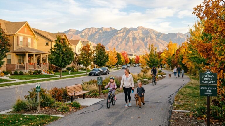
Walking, biking, trails, and active transportation
South Jordan’s transportation story is not only about cars and TRAX. Trails, sidewalks, bike routes, and active transportation planning can change how a neighborhood feels. If you walk, bike, run, push a stroller, or want easier park access, this part of the decision matters.
South Jordan City’s Active Transportation planning resources describe bicycle and pedestrian planning, and the city has noted work on the Bingham Creek Trail Extension, a 6.3-mile multi-use trail intended to connect the Jordan River Parkway Trail, Bingham Creek Regional Park, and the Mountain View Corridor Trail.
| Active transportation factor | Why it matters | What to verify |
|---|---|---|
| Sidewalk continuity | Sidewalk gaps can turn a short walk into an uncomfortable route. | Walk the route from the home to parks, schools, trails, or stations. |
| Trail access | Trails can support walking, biking, running, and family routines. | Find the actual trail entry point and test crossings from the property. |
| Road crossings | Wide roads and high traffic can make nearby amenities feel less usable. | Check crossings at the time you would actually walk or bike. |
| Bike comfort | A route may be technically bikeable but stressful for casual riders. | Check bike lanes, traffic speed, protected space, and your own comfort level. |
| First-mile/last-mile access | Transit only works if getting to and from the station feels practical. | Time the walk, bike, drive, or drop-off route to the station. |
South Jordan’s Active Transportation Plan was designed to examine bicycle and pedestrian facilities and identify sidewalk, trail, and bike-lane needs. South Jordan City’s 2025 update on expanding trails describes the Bingham Creek Trail Extension as a 6.3-mile multi-use trail connecting the Jordan River Parkway Trail, Bingham Creek Regional Park, and the Mountain View Corridor Trail.
Current projects and route-change checks to review before you make an offer
Transportation content gets outdated quickly because roadwork, transit service, trail construction, event traffic, and development sequencing change. Use this section as a buyer checklist, not a promise that every project will affect every home.
| Project or access change | Current source-backed context | Buyer relevance | What to verify now |
|---|---|---|---|
| Bangerter Highway interchanges | South Jordan City reported in November 2025 that the 9800 S, 10400 S, and 11400 S Bangerter intersections in South Jordan are complete. | Can improve predictability, but ramps, merges, and east-west access patterns still need to be tested from the exact home. | Drive Bangerter access during morning and evening windows and check UDOT current conditions before relying on a route. |
| South Jordan Downtown TRAX Station | UTA opened the station March 26, 2025, adding a third Red Line station for South Jordan and southwest Salt Lake County. | Important for Downtown Daybreak, the Ballpark at America First Square, and buyers who value transit near an entertainment node. | Walkability, event-night traffic, parking, Red Line schedule, transfer needs, and winter practicality. |
| Route 219 and South Jordan FrontRunner context | South Jordan City described Route 219 as serving the Redwood Road corridor and noted continued FrontRunner access near 10300 S / South Jordan Gateway. | Useful for buyers who need options beyond driving, especially in specific east/west and north/south travel patterns. | Current UTA schedules, stop access, paratransit coverage, park-and-ride needs, and full door-to-door timing. |
| Bingham Creek Trail Extension | South Jordan City describes a 6.3-mile multi-use trail planned to connect the Jordan River Parkway Trail, Bingham Creek Regional Park, and Mountain View Corridor Trail. | May improve bike/walk/recreation connectivity and make some pockets more useful for active-transportation routines. | Trail phase, access point from the home, crossings, construction status, lighting, and seasonal use. |
| Shields Lane Multi-Use Trail | South Jordan’s 2026 infrastructure update says the city is studying a first phase along Shields Lane / 9800 S, with construction expected to begin in 2027. | Potential future bike/pedestrian benefit for east-west movement, but not something to treat like an open amenity today. | Study status, funding, timeline, school-route impacts, and whether the specific address benefits. |
| U-111 Extension and Mountain View Corridor work | South Jordan’s 2026 infrastructure update notes U-111 widening/realignment context and utility work along Mountain View Corridor ahead of a future mainline freeway. | Important for west-side and regional mobility, especially for buyers comparing South Jordan, Herriman, Riverton, and Daybreak-area access. | UDOT project pages, utility-work notices, detours, long-term freeway plans, and your backup route. |
Use South Jordan City, UTA, and UDOT updates as starting points, then verify the exact property route. A citywide transportation improvement may help one pocket and barely affect another.
School + commute: the two-routine lens
For families, transportation is almost never just a work commute. It is school drop-off, pickup, activities, errands, work, and home — often in a compressed window. This is where South Jordan pocket selection becomes very personal.
A home may be close to work but awkward for school. Another may be near school but create backtracking before work. Another may be close to TRAX but not close enough to make the station useful in bad weather. The right answer depends on your full route, not one destination.
| Scenario | What can go wrong | How I would test it |
|---|---|---|
| School west, work east | Morning backtracking can turn a manageable commute into a stressful one. | Run school drop-off plus work route as one continuous trip. |
| Multiple children, different schools | Different bell schedules and routes can create daily friction. | Map the full morning and afternoon loop, not one school at a time. |
| TRAX commuter with school drop-off | Station parking, timing, and drop-off route may not line up neatly. | Test the complete sequence: home, school, station, destination. |
| After-school sports or lessons | Evening routes may be harder than the morning commute. | Map work return, pickup, activity, dinner, and home together. |
How transportation should shape your South Jordan home choice
Transportation affects the home decision more than buyers sometimes expect. It changes your stress level, your schedule, your fuel costs, your school routine, your activity access, and even how often you use local amenities.
The goal is not always to find the shortest commute. The goal is to find the most reliable routine.
| If you value… | Look for… | Watch out for… |
|---|---|---|
| Predictable work commute | Multiple route options, clean access to your main corridor, and limited first-mile friction. | Homes that look close but require awkward neighborhood exits or high-delay intersections. |
| TRAX access | Practical station route, parking or walkability, schedule fit, and useful final destination. | Assuming station proximity matters if the full door-to-door trip is inconvenient. |
| School routine | Easy drop-off/pickup, manageable school traffic, and route alignment with work. | Backtracking, multiple school routes, and school-zone congestion during real times. |
| Low-friction errands | Grocery, pharmacy, quick dinner, and service stops inside a realistic weekday loop. | Commercial areas that are close in miles but frustrating at peak times. |
| Walk/bike lifestyle | Sidewalks, trail access, safe crossings, and destinations worth walking to. | Relying on “near trail” language without testing the route from the home. |
For sellers, transportation matters too. A strong listing should not just say “convenient location.” It should make the convenience specific: access to Bangerter, nearby TRAX, easier school routes, local parks and trails, or a practical errands loop — while avoiding unsupported commute-time promises.
The no-guesswork transportation verification checklist
Before you choose a South Jordan home, I would verify the transportation pieces that affect your actual week. This is not meant to slow you down. It is meant to prevent a mismatch you feel every day after closing.
- Test the commute at your real time.
Do it on a weekday, not a weekend. Use your actual work destination and departure window. - Add school routing if relevant.
The school route can change the whole commute picture. Test the combined route. - Check TRAX as a full door-to-door trip.
Include walking, driving to the station, parking, waiting, transfers, and the final-mile route. - Review UTA schedules and alerts.
Transit works best when the schedule fits your real needs. Confirm current timing before relying on it. - Check UDOT construction and road updates.
Bangerter, Mountain View Corridor, U-111, and local east-west routes can change with construction phases, lane shifts, utility work, and interchange access patterns. - Compare the nearest station against the easiest station.
South Jordan Parkway, South Jordan Downtown, and Daybreak Parkway may all serve the Red Line, but the best station depends on parking, walking route, event traffic, and schedule fit. - Run an event-day check if you are near Downtown Daybreak.
The ballpark and entertainment district can be a lifestyle advantage, but buyers should test traffic, parking, sound, and walking comfort when activity is happening. - Visit the pocket after work.
Weekday evening tells you more about parking, neighborhood flow, traffic, and route stress than an open house. - Map your errands loop.
Grocery, pharmacy, quick dinner, school, activities, and home should be tested as one practical route.
For address-level transportation research, use UTA schedules and service alerts, UDOT current conditions and project pages, South Jordan city planning resources, and real-world route testing. Public datasets and maps are useful, but your actual commute depends on timing, weather, school schedules, construction, and route preferences.
FAQ: South Jordan transportation and accessibility
Want a commute snapshot before you choose a South Jordan home?
Send me the listing, your work anchor, and any school or activity routes that matter. I can help you think through the practical commute picture: Bangerter, I-15, Mountain View Corridor, the right TRAX station, Downtown Daybreak event patterns, school overlap, errands loop, and whether the pocket fits the way you actually move through the week.
Reminder: Confirm commute times, UTA schedules, UDOT construction updates, school routes, road conditions, HOA parking rules, and transit access using official sources and real-world testing for the specific address.